An Adventure Across the Alaskan Panhandle
Welcome!
One of the most classic of milk runs with some of the greatest scenery you’ll find, coupled with the harsh, unpredictable weather of Southeast Alaska – this promises to be one of the most exciting adventures in commercial aviation, ever!
The History of the Alaskan Milk Run
The Alaskan Panhandle is one of the most remote populated regions in the world. Isolated from Canada and the rest of the state by the Coast Mountains, St Elias Mountains and Chugach Mountains, as well as various glaciers and fjords, it offers some of the most breathtaking and unique scenery you’ll find in Alaska.
The region has a unique history, with many of these towns seeing themselves established and playing important roles during the gold rush of the early 1900s, and later pivoting to fishing and tourism once the mining industry moved north into inland Alaska. The region was historically the centre of economic activity and the most populous in Alaska, with Sitka and now Juneau selected as the state capitals. This was before Anchorage sprung up due to its superior geographical location, influencing much of its development as a transportation and industrial hub.
Today, the two largest contributors to the economy of Southeast Alaska are fishing and tourism. The region boasts one of the most diverse salmon and cod catches in the world, with USD 829 million of seafood processed in 2022, contributing to almost 20% of the region’s gross domestic product. The tourism industry accounted for 6,570 jobs, paying out USD 242 million in wages in 2022, with the cruise industry contributing 1.18 million out of 1.65 million total visitor arrivals. The public sector is the largest employer in the region, accounting for 12,644 jobs and 32% of all wages in Southeast Alaska.
Ketchikan is a prime example of a town with such a dual role, playing host to 1.18 million cruise passenger arrivals in 2019, at the same time home to a thriving fishing industry, with the nickname “King Salmon Capital of the World”.
The full series of reports on the economic performance and composition of Southeast Alaska is available for download here.
Now that we’ve established why these settlements exist, let’s take a look at why these milk run flights are operated, and why their role is vital to the communities they serve. Have a look at this connectivity map of Alaska, courtesy of RV Alaska. The red lines represent road connectivity, and the blue lines form the Alaska Marine Highway network.
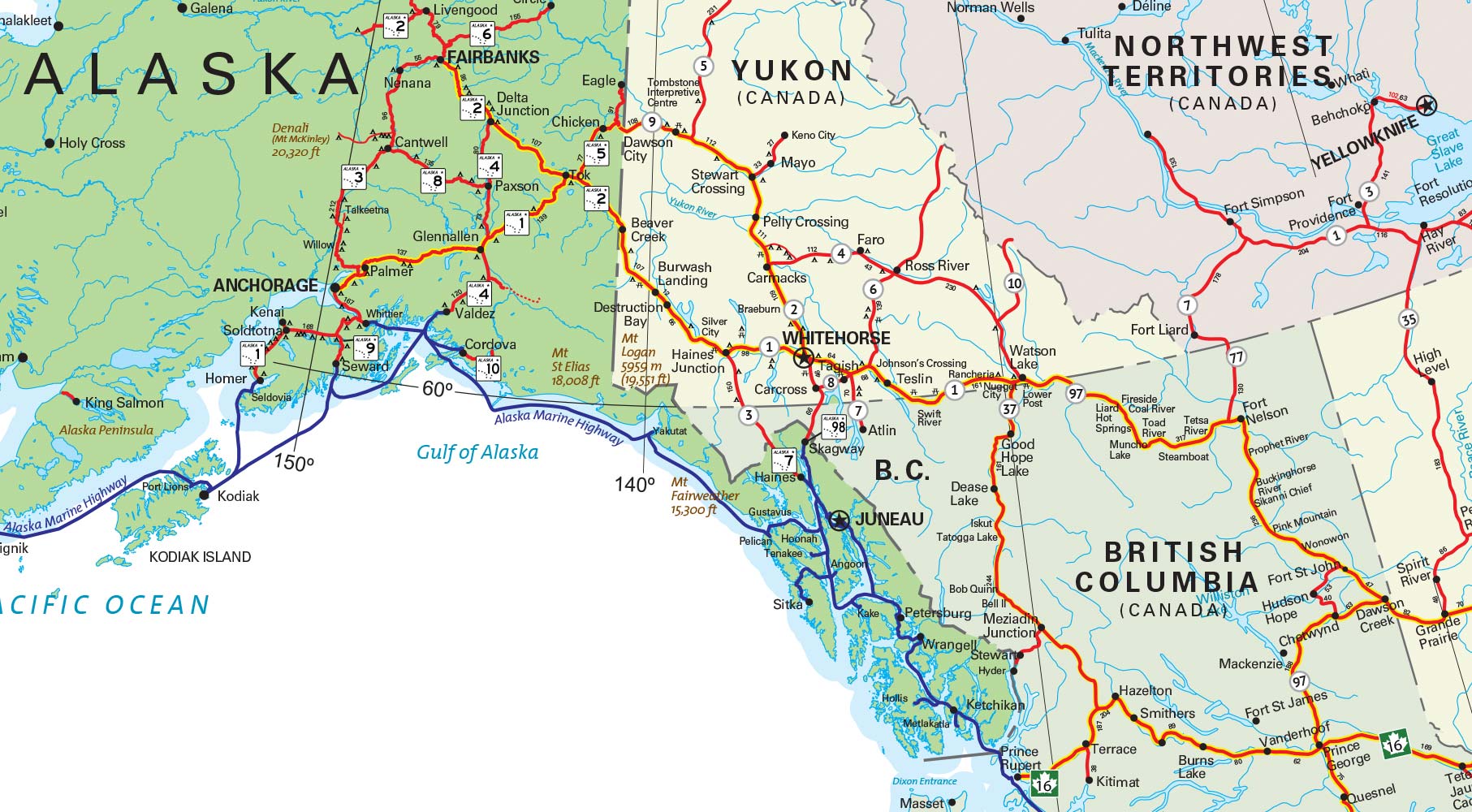
You’ll notice that indeed, there are no road links along much of Southeast Alaska. In particular, Ketchikan, Wrangell, Petersburg, Sitka, Yakutat, Cordova and the state capital, Juneau, are only accessible by nautical means, through the Alaska Marine Highway System, which is a state-run ferry service. The other alternative, of course, is by air.
Why, then, are there no roads connecting these towns and cities with the rest of the world? The reason is twofold – economics and environmental impact.
Firstly, let’s examine the population data for the towns and cities visited by the Milk Run flights, with data sourced from the US Census Bureau’s 2022 American Community Survey.
Juneau – 32,108
Sitka – 8,462
Ketchikan – 8,168
Petersburg – 3,317
Cordova – 2,507
Wrangell – 2,134
Yakutat – 564
Apart from Juneau, which is the state capital, the population for these communities are small. The terrain separating much of the Panhandle from Canada and the rest of Alaska is mountainous, with tall peaks and shifting glaciers making up much of the landscape. Studies have been conducted since as far back as 1993 on the feasibility of a 51-mile road linking Juneau to a yet-to-be-constructed ferry terminal 18 miles southeast of Skagway, a town linked with the rest of the Alaskan road network. Dubbed the Juneau Access Improvements Project, the total project life cost, with an assumed operational period of 30 years, was estimated to be as high as USD 1.964 billion back in 2016 dollars. This is contrasted with the USD 895 million projected total project cost of the current ferry service over the same period. Due to the need for the road to cut through the Tongass National Forest, it would have meant significant impact to wildlife, as well as high capital and operating costs due to the challenging terrain and weather that such a road would have to stand up to.
All the proposals would have had negative net present values, with the highest running up to USD (351 million), in simple terms meaning that that they would all be unprofitable compared to simply running the ferry service.
There was also significant lobbying against the proposed road project by the Southeast Alaska Conservation Council, with the study culminating in a 2016 decision by the State of Alaska on “No-Action”, and an approval of the decision by the Federal Highway Administration in 2018, effectively shutting off the possibility of a road project linking these towns in Southeast Alaska to the rest of the Alaskan highway network. If Juneau, the state capital, with a population almost 4 times that of other towns in the Southeast won’t be linked, it is unlikely that we’ll see linkage to other towns and cities anytime soon. Indeed, one of the 4 main goals of the Southeast Alaska 2025 Economic Plan is to sustain and support the Alaska Marine Highway System.
The full, highly detailed 598-page report on the proposals, including analyses on the environmental and economic impacts is available for download here.
All in all, the ferry service and flying in and out of Juneau remain the only options available for a connection to the state capital, and will likely remain the case for the foreseeable future.
With no road access, these milk run flights play a vital role in delivering time-critical supplies to these remote towns in Alaska. Vaccines, medical supplies, mail, perishable consumables such as, yes, milk, and many others fly in the belly of these 737NGs, together with patients who need access to advanced medical facilities in Anchorage and Seattle, as well as workers who commute to and from these towns on a regular basis.
A trip via road coupled with the ferry service would simply take a much longer time, with a journey from Anchorage to Juneau taking approximately 20 hours, even with the ferry from Haines to Juneau taking approximately 5 hours to cover a distance of 65 miles as the crow flies, with the ferry ride alone costing USD 80. This is in stark contrast to the 1.5 hour flight at a cost of USD 190.
Alaska airlines themselves puts it nicely,
“The Milk Run flights have been living up to their nickname for many years, with Alaska Airlines delivering milk and other vital supplies to the towns it serves. Many towns in Alaska are uniquely reliant on air service, due to the lack of roads.”
The Chosen Ones
Why then, you ask, have those specific stops been chosen for the milk run flights?
Now, these milk run flights go back a long time, back when economies. But, if we take a look at the current population density across Southeast Alaska, the data is rather telling – along the route from Anchorage to Seattle, the settlements with the largest populations coincides beautifully with the airports the milk run flights stop at, with the notable exception of Yakutat, which we’ll go into a bit later.
Have a look at these 3 pictures below. The purple circles represent the relative population size for each settlement. Anchorage has been left out because it would completely dwarf every other circle in its area. All 3 images use the same scale, both in distance and the area of the circles. For reference, Juneau has a population of 32,108, and Yakutat has one at 564.
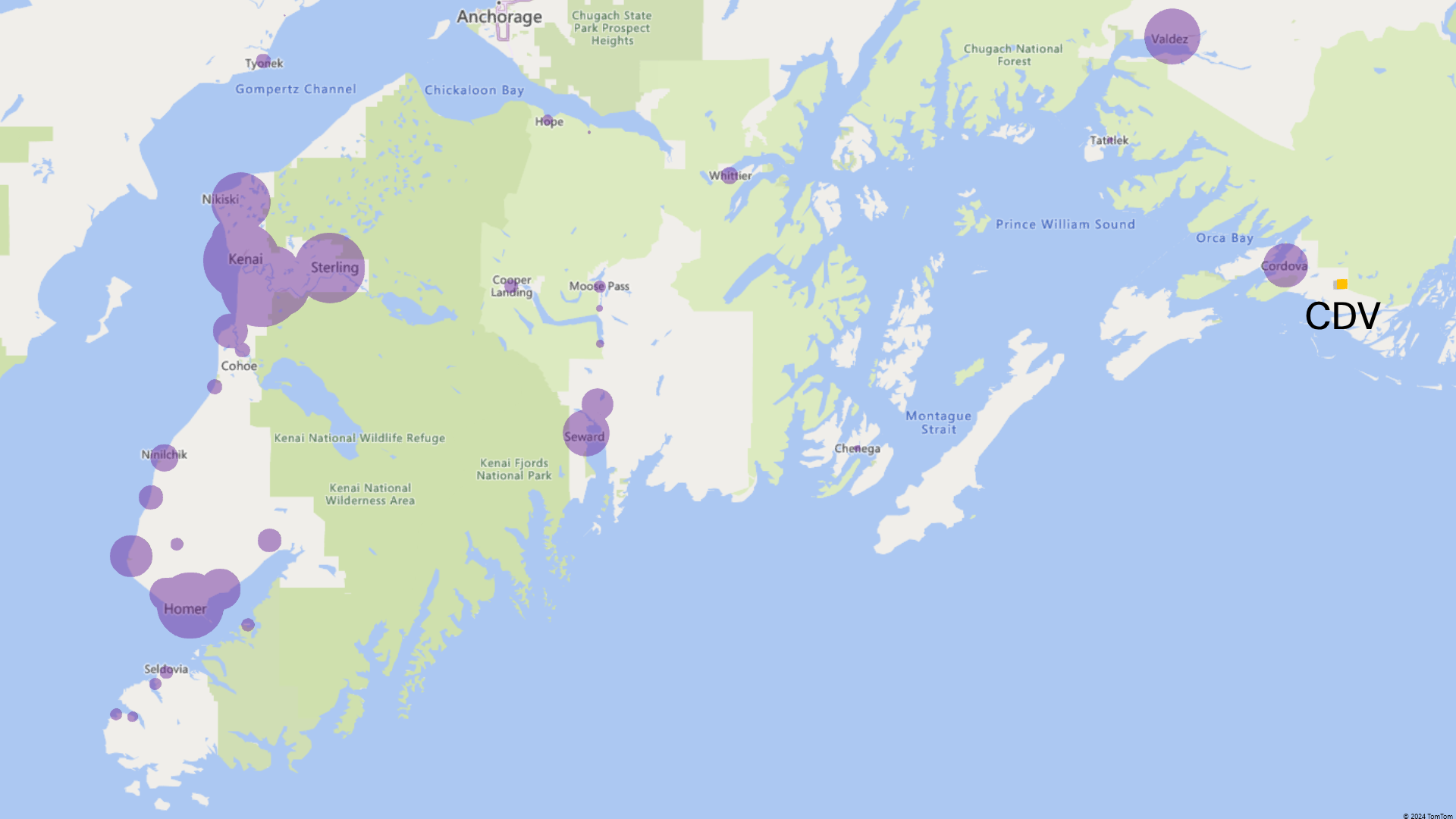


There are no settlements at all between Yakutat and Cordova, due to the presence of the St Elias Mountains, with a peak elevation of 19,551 feet. The cold climate and mountainous terrain, with numerous fjords and glaciers, while rendering the area largely impassable, makes for one of the most breathtaking views in the world if you’re seated on the right hand side, as you’re about to see later.
The large settlements you see northwest and westwards of Cordova are all linked to the Alaskan road network. Perhaps for this reason, none of them receive regular scheduled commercial flights from Alaska Airlines.
Why is Yakutat a stop on these flights but not places like Gustavus or Klawock? Now I don’t work at Alaska Airlines, so I can’t say for sure, but we can make a few inferences based on publicly available data.
The first possible reason is the amount of subsidies provided by the government. Alaska Airlines receives a subsidy of USD 4.35 million a year to operate passenger services to Yakutat. Considering the population of only 564, and the extra fuel costs associated with taking off and landing at Yakutat, and the time costs associated with the extra stop, we can estimate that . The sheer remoteness of Yakutat, together with the important contribution it has to the Alaskan economy likely compelled the government to provide such a large subsidy for these Yakutat flights. A similar story exists in Cordova, with the airline receiving USD 4.32 million a year to continue its passenger service.
It is possible that the subsidies for Gustavus were simply not appealing enough, given the relatively short distance to Juneau.
Klawock would have been an attractive destination for the milk run, but it seems that at present, the airport is simply not large enough to accomodate the heavier 737NG aircraft that Alaska Airlines flies, compared to the turboprop aircraft that it usually sees.
It may well be the case that the very existence of these milk run flights further spurred the development and growth of these settlements. To see if this is true, we’ll need to examine historical population data. Even so, there are a myriad of other factors that could have influenced the growth of these towns. Anchorage for instance, grew significantly in the late 1950s as a result of…
We can also look at historical flight schedules for these airports, courtesy of Flightsim Dispatch
The above diagrams are courtesy of population data from 355 settlements across Alaska, retrieved from the US Census Bureau’s 2010 and 2022 American Community Survey, visualised with the help of Microsoft Excel’s 3D Maps feature.
The simple answer is that these are the largest airports in the region capable of handling 737 operations. (But it might be that these airports expanded for milk run ops)
Visual Departures and Approaches
Because we don’t have access to the Alaska Airlines proprietary RNP approach and departure procedures, along with their associated charts, we will improvise a little and do what is actually allowed and frequently flown in real life under good weather conditions – visual departures and approaches. We’ll analyse what these entail for each of the 7 airports along the Milk Run in detail below.
Juneau International Airport (PAJN/JNU)
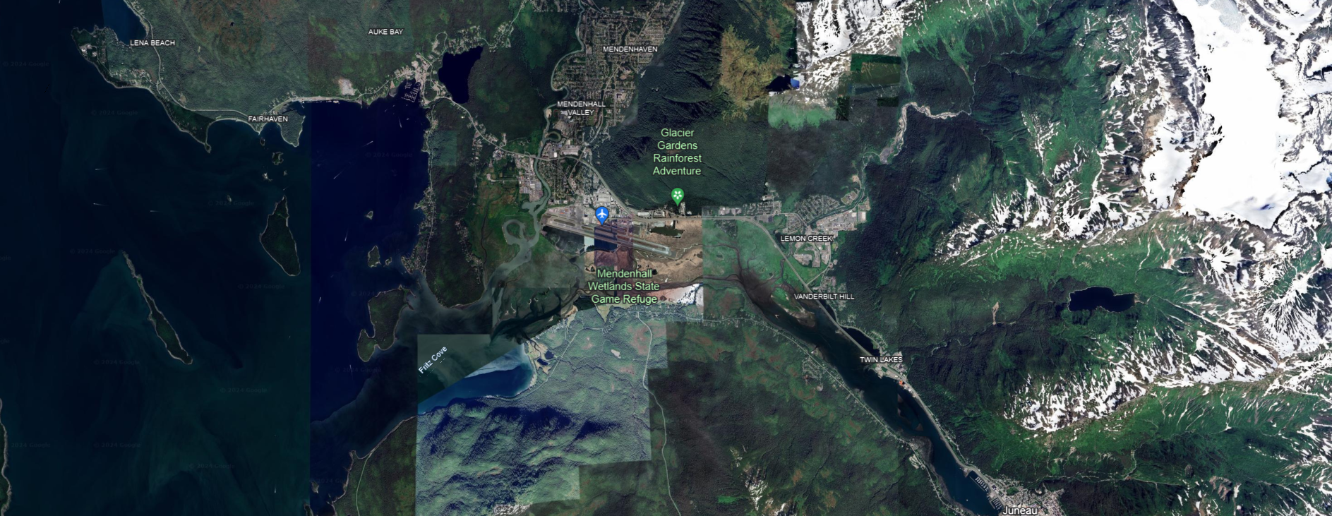
Juneau Airport sits in right in the Mendenhall Valley, with the airport aligned east-west and sandwiched between peaks to the north up to 5,000 feet, and south on Douglas Island up to 2,500 feet.
Have a look at these 3 images from Google Earth below. The first image shows the view looking east into the Gastineau Channel, and the second shows the view looking west with the mountains of Excursion Inlet framing the background. The third shows an aerial view with true north facing up.
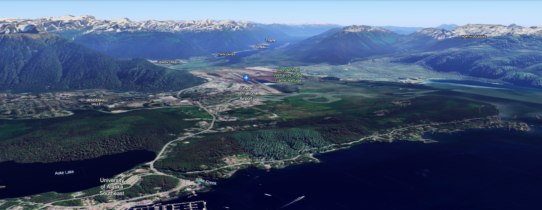

If we have a look at the list of published FAA approach procedures, we will find that there are none for runway 26, due to the need for aircraft to fly through the Gastineau Channel and navigate the complex terrain in the area. Alaska Airlines, however, has developed RNP approaches to runway 26 that have aircraft pass through the Gastineau Channel. on their way into the airport.


Leave a comment